Popular Subjects
Buy Bulk Books
600-900 books per box.
More information
Buy Books
by the Foot
Decorator collections available.
More information

Members Savings Club
Join & Save at least 5% every day
Join and be notified of "Members Only" sales and discounts. Save from 5% to 50% on all items ordered!
If you haven't already done so, sign-up and save at least 5% today.
Sign-Up Now
Help

Podcast
Listen to the Zubal brothers unload about things in the book trade that make them smile or give them the feelings that their heads may explode!
Listen Now
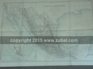
Expedition du Mexique, 1861-1867 [Atlas]
Gustave Leon Niox
/ Librairie Militaire de J. Dumaine 1874
the atlas volume only; folio, 5 maps, viz: Carte du Mexique, large color folding map measuring 43 x 32 inches; Combat des Cumbres (28 Avril 1862) Combat de la Barranca-Seca (18 Mai 1862), single page measuring 12 x 16 inches; Environs d'Orizaba, single page measuring 12 x 16 inches; Plan de Puebla et des Environs, double page measuring 24 x 16 inches; Plan d'Oajaca, double page measuring 24 x 16 inches; in a contemporary cloth-backed board portfolio, old library markings to the cover, hand stamp to the front blank, the verso of the large folding map and a margin of the Cumbres plate, small dark stain from a liquid drop to the upper corner of the Orizaba plate, balance of the images have light to moderate foxing, the large folding map has a few closed tears to the folds. Volumes
Included: 1
ISBN: NA
Subject/Keywords: western americana mexico texas office
Item #: 1000923
Request a photo for this item.
$4,330.65